Location:
Latitude(D/M/S) = 38 Degrees, 20 Minutes, 5.4 Seconds
Longitude(D/M/S) = 80 Degrees, 16 Minutes, 49.8 Seconds
Latitude(D/M.mmm) = 38 Degrees, 20.09 Decimal Minutes
Longitude(D/M.mmm) = 80 Degrees, 16.83 Decimal Minutes
Latitude(D.ddd) = 38.33483 Decimal Degrees
Longitude(D.ddd) = 80.28050 Decimal Degrees
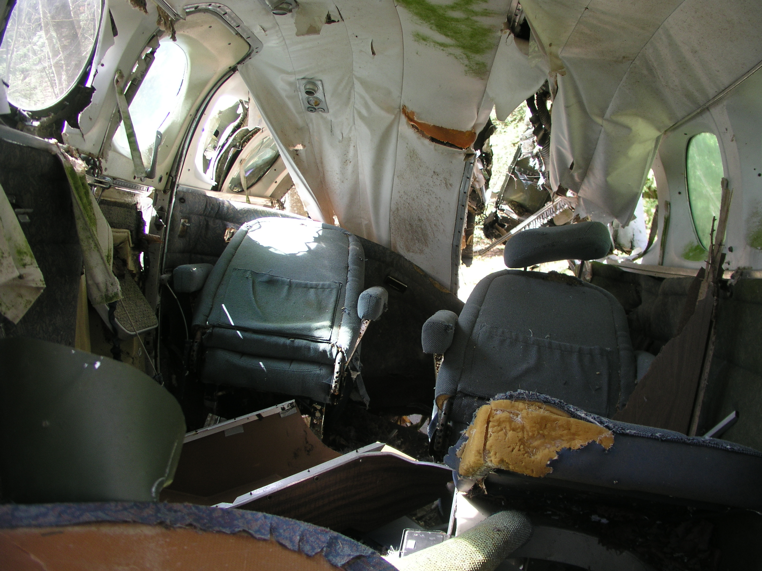
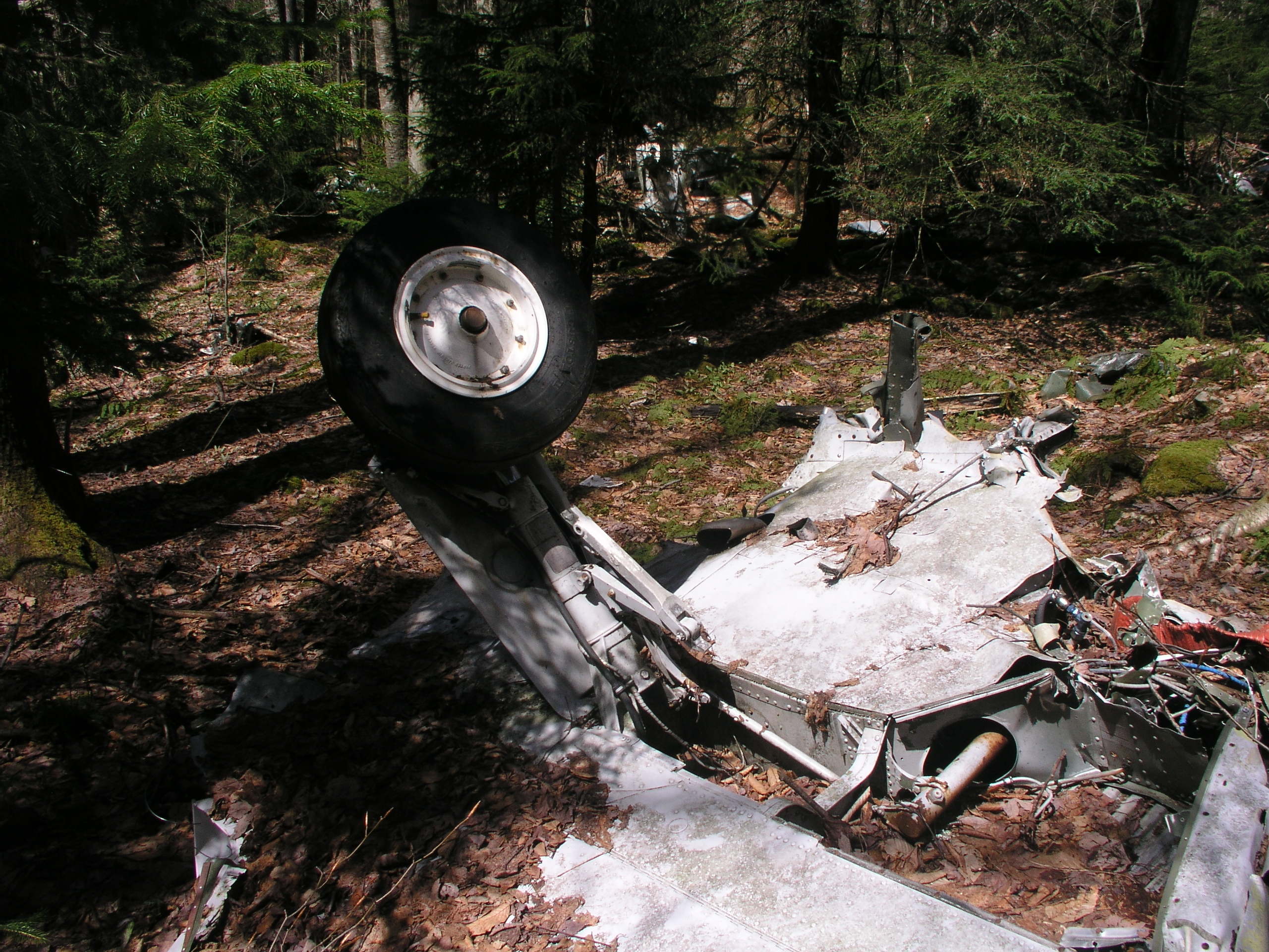
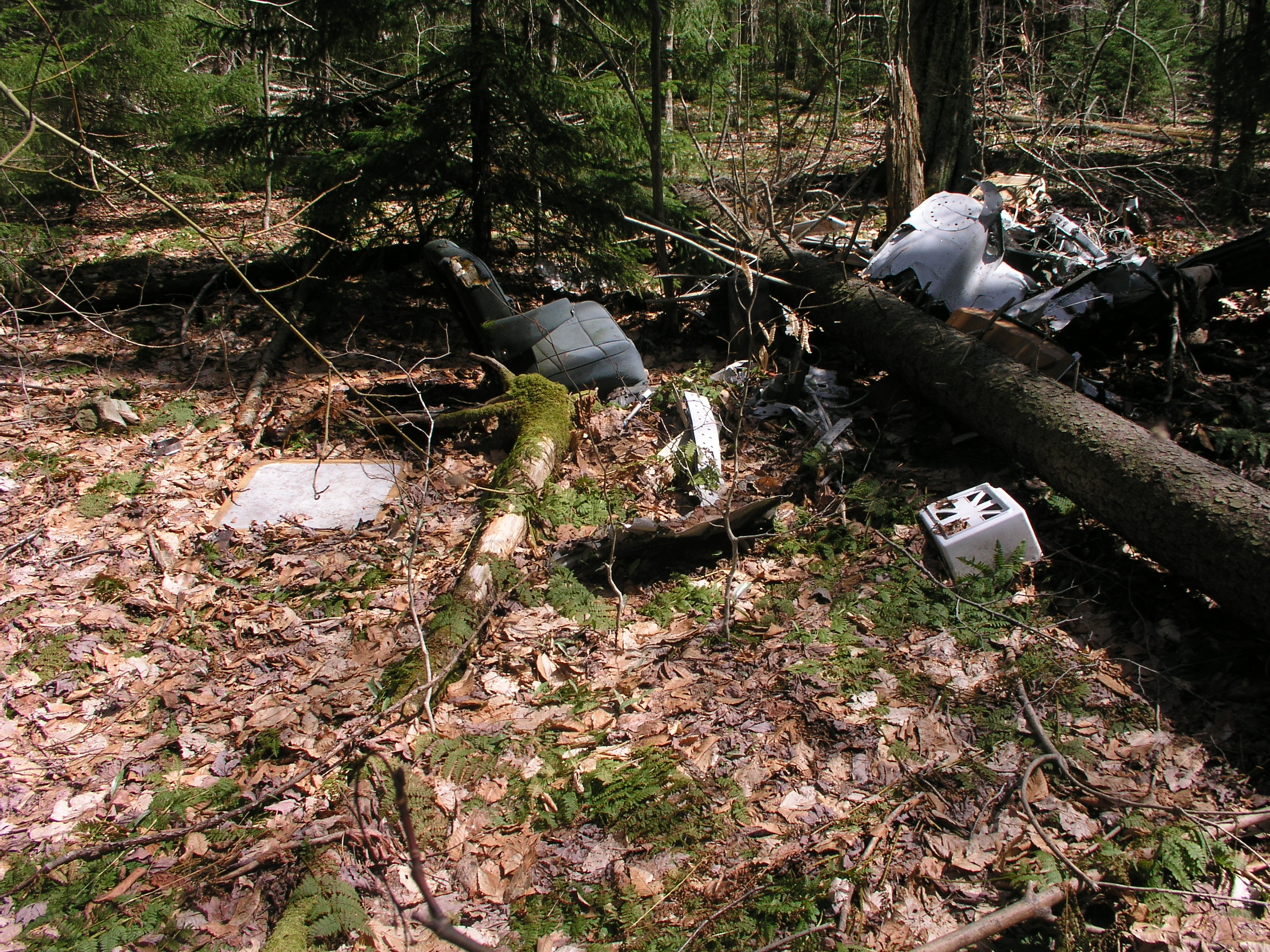
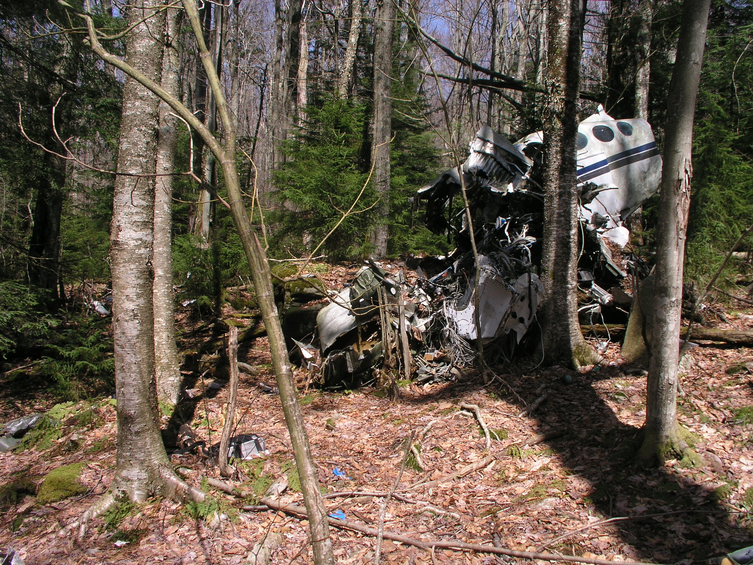
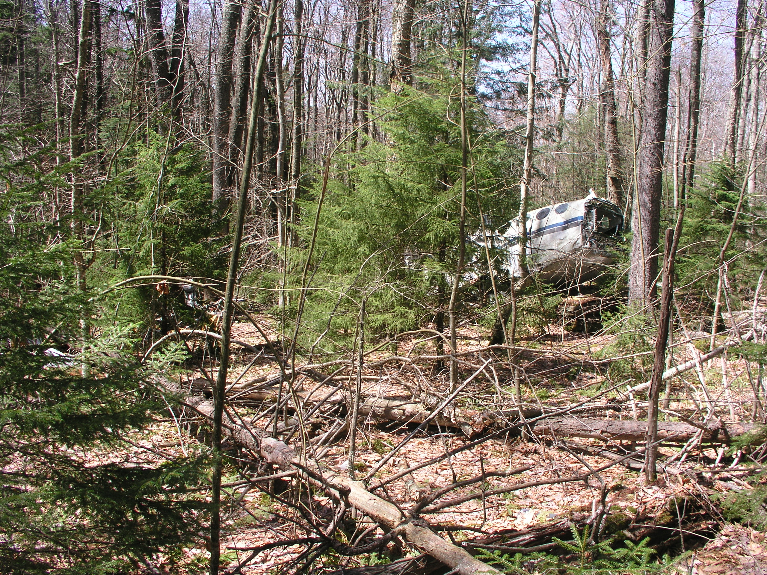
The photos above were taken by me when I found the site back in 2006. The terrain is very rugged and it is quite a bushwhack from the nearest trail, which would be the County Line Trail. Below is some data and a news story I found online. Much more info from the NTSB site can be found here.
WRECKAGE INFORMATION
Initial tree impact marks were at 38 degrees, 20.09 minutes north latitude, 80 degrees, 16.83 minutes west longitude
The wreckage was located on rising terrain, about a 5-degree incline, in the Cranberry Wilderness Area of the national forest, about 28 nautical miles southeast of Braxton County Airport. The wreckage was located approximately along a direct line between the airport and Lynchburg.
A debris path, consisting of broken tree branches and airplane wreckage, was about 500 feet in length. The first 100 feet was oriented on an axis of approximately 140 degrees magnetic. The remainder was oriented on an axis of approximately 155 degrees magnetic.
The wreckage path began in the tops of trees estimated to be 80-100 feet tall. Initial tree cuts appeared to be relatively level, with subsequent tree cuts, after the change in the wreckage path direction, descending at an angle of approximately 5 degrees. Some branches were found cut at a 45-degree angle. The main wreckage was located at an elevation of approximately 4,050 feet msl.
There was no evidence of pre-impact airframe or engine malfunction. Both engines were separated from the airframe, and both sets of propellers were separated from the engines. Five of the six propeller blades could be moved freely within the hubs. The sixth blade was separated from the hub. The blades had varying degrees of bending, some with severe bending at the tips. Most of the blades had leading edge damage, and several also had trailing edge damage.
Flight control continuity could not be confirmed due to the positioning and extent of wreckage, although some control cables exhibited “boom straw” separation. Engine control positions were unreliable due to impact damage.
The three landing gear were found extended. However, there was almost no leading edge damage to any of the gear or gear doors, and the landing gear actuator position indicated that the landing gear had been retracted.
The instrument panel was destroyed. Individual gauges revealed a course dialed into the HSI of 135 degrees magnetic and the heading indicated 140 degrees magnetic; the altimeter indicated about 4,000 feet, however, the face plate was broken and movement of the needle revealed no slap marks; the RMI indicated 120 degrees; and the turn coordinator indicated ½ standard rate turn to the right.
281195
Cessna 414 Chancellor
Casey Industrial
Marlinton, WV
WEBSTER MAN’S TENACITY PAYS OFF AFTER 6-YEAR HUNT, FINDING CRASH SITE PROVIDES ‘CLOSURE’
Publication: THE CHARLESTON GAZETTE
Published: 11/17/2001
Page: 1A
Byline: RUSTY MARKS
rustymarks@wvgazette.com
For six years, Dwayne McCourt was almost certain he knew where to find the wreckage of Colin Campbell’s twin-engined Cessna.
McCourt, a Webster County pawnshop owner and paragliding instructor, was sure the plane Campbell crashed on Nov. 28, 1995, was in the Cranberry Wilderness.
“I’ve been within 100 feet of it twice, walking, and within 300 feet three or four times,” McCourt said Friday.
McCourt even walked over debris from the wreckage once, but the snow was so deep he didn’t see anything.
On Wednesday, McCourt got lucky and spotted the wreckage from an airplane. McCourt had flown over the crash site Tuesday with Webster County coroner and pilot John Reed, but it was too dark to see the plane.
Wednesday morning, McCourt decided to make one last aerial search of the site where he thought the plane went down. “I told my wife I’m going to find his butt today or I’m done,” he said.
Every fall, when the leaves drop, pilots in the area would search the backcountry for signs of the missing plane. McCourt figures he’s flown over the crash site 25 times in the past six years and walked the woods around the area hundreds of times looking for clues to Campbell’s whereabouts.
But the weather was too good Wednesday not to look. “There are very, very few days in the spring and fall when there are no leaves and no snow,” McCourt said. The chances of finding a white airplane in snow that is often 30 inches deep are slim.
McCourt got pilot Lee Wolfe to take him up for one last aerial search Wednesday morning. They spotted Campbell’s plane just past noon.
But McCourt wanted to be sure. The pair landed, picked up paragliding buddy Tim Englekemier and started walking into the backcountry, a federal wilderness area that is strictly off-limits to any motorized vehicle.
It was dark by the time the three got the site, so the group bedded down near a piece of aircraft seat. At first light, they set off again, and found the debris field within minutes. The plane turned out to be within 900 feet of a spot McCourt had marked on a map as a possible crash location when the plane originally went down.
Campbell, a pilot for Oregon-based Casey Industries, left Braxton County Airport in Flatwoods at 9:30 a.m. Nov. 28, 1995, bound for his home in Lynchburg, Va. Casey employees had been building the Weyerhaeuser plant near Flatwoods.
Campbell was last spotted just south of Webster Springs, and disappeared from radar screens minutes later. Despite an exhaustive search in the snow in the days after the crash, the plane was never found. Officials for Casey Industries offered a $5,000 reward if the plane were ever found.
McCourt said searchers did all they could at the time, but the weather was so terrible it was dangerous to even be out in the woods.
But McCourt, who grew up navigating the backcountry looking for archaelogical sites and Civil War encampments, never gave up on finding the plane. “I just couldn’t quit,” he said. “I wanted the family to have closure. And I was ticked off that I couldn’t find it.”
When McCourt found the wreckage early Thursday, the airplane registration number confirmed it was Campbell’s plane. County officials went to the site on Friday to search for remains. Federal aviation officials were to visit the crash site today.
To contact staff writer Rusty Marks, use e-mail or call 348-1215.
I have a pilot/friend I lost touch with after college in 1986 named Colin Campbell. I was wondering if this was my friend. He was originally from Lexington, KY. I met him at Kent State University.